Overview
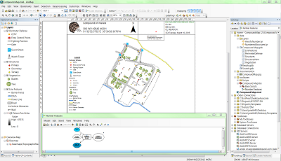

The Compound Map solution lets you rapidly sketch a compound's perimeter defense features and key structures. Analysts use this solution to digitize structures, vegetation, security measures, and more. The solution also includes a tool to systematically number the structures for easy identification.
Requirements
Compound Map requires specific technical experience and software. Minimum system requirements for the ArcGIS Platform can be found on the Support website.
| Requirement | Description |
| Experience |
|
| Software |
Map Authoring
|
What you get
When you download the Compound Map solution, the download includes the following:
| Directory | Folder | Item | Description |
| ArcMap | |||
| CompoundMap.mxd | An .mxd document to get started with the Compound Map workflows. | ||
| Data | layers | Folder containing .lyr files used to symbolize output from geoprocessing tools. | |
| Results.gdb | A file geodatabase that stores the results from geoprocessing tools. | ||
| Scratch.gdb | A file geodatabase that holds temporary data created during geoprocessing. | ||
| CompoundMap.gdb | A file geodatabase that contains the example data for the template. | ||
| toolboxes | scripts | A folder containing the NumberFeatures.py file for systematically numbering points | |
| CompoundMapTools.tbx | A toolbox containing the Number Features tool. | ||
| Resources | Compound Map.pdf | A .pdf file that contains the offline version of the documentation for the template. |
What's new
Below are the release dates and notes for Compound Map. If you need support, please contact Esri Support Services. If you'd like to get help from other military and intelligence community members, post your question on GeoNet.
| Version | Description |
| September 2017 |
|
| 5.0.0 |
|
| 4.0.0 |
|
| 3.0.0 |
|
| 2.0.0 |
|
| 1.0.0 |
|
You may be interested in
... related solutions that can be configured for your organization: