This item has been moved to mature support. Capabilities are included in ArcGIS Pro 2.6 and later. Capabilities for ArcGIS Pro 2.2-2.5 and ArcMap 10.4.1-10.8.1 are available with Military Tools for ArcGIS.
Overview

Visibility components are created for the ArcGIS Platform, allowing analysts to better understand the terrain. An analyst can assess:
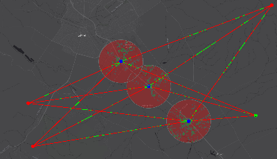
- Radial Line Of Sight, also known as Viewshed, calculates the visibility of an area from one or more observer locations. The results show what areas are visible (or not) to one or more observers.
- Linear Line Of Sight is a point to point visibility between one or more observers, and one or more targets. Each observer and target pair is a unique line of sight between them.
Requirements
The specific software and system requirements for the Visibility solution are listed below.
| Requirement | Description |
| Software |
|
What you get
Visibility includes the following:
| Component | Folder | Description |
| ArcGIS Pro | ArcGIS Pro 2.2-2.5 | Contains Visibility.esriAddinX |
| ArcMap | ArcMap 10.4.1-10.8 | Contains the Visibility.esriAddIn |
| Visibility in ArcGIS.pdf | Help documentation for Visibility | |
| Visibility Online Help | Internet shortcut to online Visibility documentation |
What's new
Below are the release notes for Visibility. If you need support, please contact Esri Support Services. If you'd like to get help from other defense community members, post your question on GeoNet.
| Date | Description |
| August 2020 |
|
| February 2020 |
|
| October 2019 |
|
| June 2019 |
|
| March 2019 |
|
| January 2019 |
|
| September 2018 |
|
| August 2018 |
|
| June 2018 |
|
| June 2017 |
|
| May 2017 |
|
Automated deployment options
With ArcGIS Pro and the ArcGIS Solutions Deployment Tool, users can now automate the deployment of this solution in their ArcGIS organization. Follow a few simple steps to quickly deploy the solution, configure it, and load your data when necessary.