This item has been moved to mature support. Please see What's new for more information.
Overview
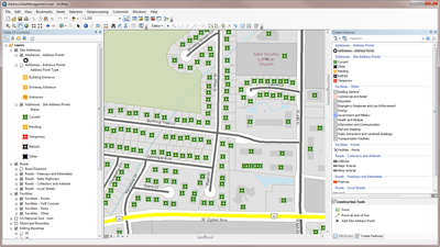
Address Data Management is a configuration of ArcMap that can be used by mapping technicians to collect and manage road centerlines with address ranges, facilities, site addresses, and related mailing address data. It can be used by planning, public safety, or land records organizations to streamline the collection, maintenance, and use of authoritative address information.
Requirements
Address Data Management requires specific software.
| Requirement | Description |
| Software | Map authoring
|
What you get
When you download Address Data Management, you'll find the following files:
| Directory | Item | Description |
| Application | AddressManagement.esriAddin | An ArcMap Add-in that includes the Address Editing toolbar and a series of construction tools that improve the editing experience when working with road and address information. |
| AttributeAssistant.esriAddin | An ArcMap Add-in that includes the Assistant toolbar and a series of predefined methods to automatically populate attributes (for example, validate road names from master street name table) when features are created and updated. | |
| MapsandGeodatabase | AddressDataManagement.mxd | A map document used to collect and manage road centerlines, facilities, site addresses, and related mailing address data. |
| LocalGovernment.gdb | ArcGIS for Local Government geodatabase with content from the City of Naperville, Illinois. |
What's new
Below are the release dates and notes for Address Data Management.
| Date | Description |
| February 2020 |
|
| March 2019 |
|
| June 2018 |
|
| January 2018 |
|
| March 2017 |
|
| July 2016 |
|
| June 2016 |
|
| February 2016 |
|
| July 2015 |
|
| December 2014 |
|
| June 2014 |
|
| December 2013 |
|
There is a newer version...
Address Data Management (ArcMap) has been moved to mature support and replaced with Address Data Management (ArcGIS Pro).