Overview
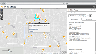
Election Polling Places is a configuration of ArcGIS Web AppBuilder that can be used by citizens to locate the polling place where ballots can be cast on election day. This application can be accessed from a smartphone, tablet, and desktop computer.
An election polling place is usually located in a public facility and used to gather and count ballots during election day. They are open during specified hours depending on the type of election, this information is presented to users when they find the voting precinct they reside in, and it's polling place.
Requirements
To deploy Election Polling Places with the ArcGIS Solutions Deployment Tool requires specific software.
| Requirement | Description |
| Software |
Solution deployment
Solution hosting
|
| Application |
|
To manually deploy Election Polling Places in your organization requires specific software.
| Requirement | Description |
| Software |
Map authoring
GIS service hosting
|
| Application |
|
What you get
Election Polling Places can be deployed in your ArcGIS organization without downloading the solution. When you deploy Election Polling Places in your organization, you'll find the following:
| Item | Name | Description |
| Application | Election Polling Places | An application used by citizens to locate the polling place where ballots can be cast on election day. |
| Map | Election Polling Places | A map used in the Election Polling Places application to locate the polling place where ballots can be cast on election day. |
| Feature layer | ElectoralDistricts | A feature layer used to store territorial subdivisions for electing members to a legislative body along with precinct and polling places. |
What's new
Below are the release dates and notes for Election Polling Places.
| Date | Description |
| March 2019 |
|
| January 2017 |
|
| June 2016 |
|
| February 2016 |
|
| December 2015 |
|
| October 2015 |
|