Overview
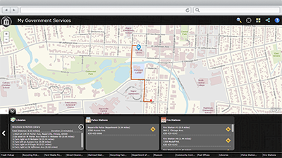
My Government Services is a configuration of ArcGIS and a JavaScript application that helps residents locate a government facility and obtain information about curbside and drop-off services provided by a government agency in their community from a smartphone, tablet, and desktop computer.
My Government Services is typically used by residents in a community, but it can be used by visitors to locate a library or post office near them. This application provides access to the organization 24 hours a day, seven days a week, and typically supplements customer service phone numbers staffed by these organizations.
Requirements
My Government Services requires specific technical experience and software.
| Requirement | Description |
| Experience |
|
| Software |
Map authoring
GIS service hosting
Application hosting
|
| Browser compatibility | The application is optimized for display on desktop computer, tablet, and smartphone devices using the following browsers:
|
What you get
When you download the My Government Services, you'll find the following files:
| Directory | Item | Description |
| Application | MyGovernmentServices | A folder containing the My Government Services application files. |
| MIXED90CacheSettings.xml | A tiling scheme suitable for the General Purpose and other basemaps. | |
| MapsandGeodatabase | GeneralPurpose.mxd | A map document used to publish the General Purpose tiled or cached service. |
| GovernmentServices.mxd | A map document used to publish the GovernmentServices service. | |
| ImageryReferenceOverlay.mxd | A map document used to publish the Imagery Reference Overlay tiled and cached service. | |
| LocalGovernment.gdb | ArcGIS for Local Government geodatabase with content from the City of Naperville, Illinois. |
What's new
Below are the release dates and notes for My Government Services.
| Date | Description |
| June 2016 |
|
| July 2015 |
|
| December 2014 |
|
| September 2014 |
|
| June 2014 |
|
| November 2013 |
|
There is a newer version...
The My Government Services application has been moved to mature support and replaced with a new My Government Services application that leverages ArcGIS Online and Web AppBuilder for ArcGIS, upgrade to take advantage of newest version