Overview
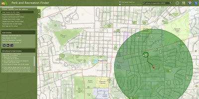
Park and Recreation Finder is a configuration of ArcGIS and a JavaScript application that allows citizens to locate park and recreation opportunities in their community from a smartphone, tablet, and desktop computer.
Park and Recreation Finder is typically used by parks departments, planning departments, facilities departments, or other local government organizations responsible for managing parks and recreation activities. This application provides access to the organization 24 hours a day, seven days a week, and typically supplements customer service phone numbers staffed by these organizations.
Requirements
Park and Recreation Finder requires specific technical experience and software.
Park and Recreation Finder is supported on ArcGIS 10.2 and 10.3.
| Requirement | Description |
| Experience |
|
| Software |
Map Authoring
GIS Service Hosting
Application Hosting
|
| Browser Compatibility |
The application is optimized for display on desktop computer, tablet, and smartphone devices using the following browsers:
|
What you get
When you download the Park and Recreation Finder, you'll find the following files:
| Directory | Item | Description |
| Application | ParksFinder | A folder containing the Park and Recreation Finder application files. |
| MIXED90CacheSettings.xml | The map server cache tiling scheme suitable for the sample data. | |
| MapsandGeodatabase | GeneralPurpose.mxd | ArcGIS for Desktop map used to publish the General Purpose cached map service. |
| ImageryReferenceOverlay.mxd | ArcGIS for Desktop map used to publish the Imagery Hybrid cached map service. | |
| Parks.mxd | ArcGIS for Desktop map used to author the Parks feature service. | |
| Trails.mxd | ArcGIS for Desktop map used to author the trails map service. | |
| LocalGovernment.gdb | ArcGIS for Local Government geodatabase with content from the City of Naperville, Illinois. |
What's new
Below are the release dates and notes for Park and Recreation Finder.
| Date | Description |
| July 2015 |
|
| December 2014 |
|
| September 2014 |
|
| June 2014 |
|
| November 2013 |
|