When your organization is ready to start maintaining your Public Lands Survey System data with the Public Land Survey Editing solution, you will need to migrate your authoritative control point and survey system dataset to the parcel fabric data model. If you do not have control points and PLSS data for your organization, you can start with the national data set and improve it over time with the Public Land Survey Editing map.
To migrate data from the Cadastral National Spatial Data Infrastructure (CadNSDI), complete the following steps:
- Using ArcCatalog or the Catalog window in ArcMap, create a Parcel Fabric and enable the Local Government Information Model.
- Download the most recent Cadastral National Spatial Data Infrastructure (CadNSDI) dataset for your jurisdiction.
- Using ArcCatalog or the Catalog window in ArcMap, create a staging Geodatabase and staging feature dataset to store intermediate layers that are used for the loading process.
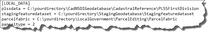
- Open the Sections.ini file from the download, update the following paths in the [LOCAL_DATA] section:
- CadNSDI data (plssdata =) from step 2
- Staging feature dataset (stagingfeaturedataset =) from step 3
- Parcel Fabric (parcelfabric =) from step 1
- Choose to Save as this file as a new one.
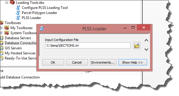
- Open the PLSS Loader tool from the Loading Tools toolbox and specify the file saved from step 4 and click OK.
- Using the configuration files supplied, repeat this process for all other parcel types (Townships, Quarter Sections, Special Surveys, and so on).
When you're ready to begin maintaining the PLSS, start by opening the PublicLandSurveyEditing.mxd. It can be used to add new control points and maintain PLSS boundaries and divisions.