The Service Qualification app requires the Service Feasibility widget, which is used to find a route (based on either shortest distance or max business potential) and save the results to a CSV file. To deploy this widget you will need to install and deploy the widget using the Web AppBuilder (Developer Edition).
Service Feasibility widget
Before configuring the app, you will need to add the Service Feasibility widget to your Web AppBuilder (Developer Edition). To deploy the widget, complete the following steps:
- In Windows Explorer, browse to the download's Applications folder.
- Deploy the Service Feasibility widget.
- Start Web AppBuilder (Developer Edition). You will now be able to configure an application using the Service Feasibility widget.
Service qualification app
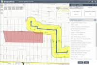
Once the Service Feasibility widget is added to your Web AppBuilder, you can configure the Service Qualification app to determine optimal routes based on shortest distance and business influence.
To configure the Service Qualification app, complete the following steps:
-
Create an app from the Service Qualification map and Web AppBuilder (Developer Edition) with the following settings:
- Name: Service Qualification
- Description: The Service Qualification app allows the user to determine optimal routes. When the route is determined, the businesses along the route can be exported to CSV.
-
Configure a new Service Feasibility widget with the following settings:
Parameter Settings Closest facility parameters Closest facility service URL: http://<yourserver>/arcgis/rest/services/ServiceQualificationRoute/NAServer/ClosestFacility or ArcGIS Online Closest Facility service proxy
Facility search distance: 20,000
Impedance attribute: LengthToBusinessRatio
Default cut off distance: 50,000
Custom attribute parameter values: Checked. Then select Business Influence and Allow User Input with a min value of 0 and a max value of 100.
Attribute lookup Attribute parameter value lookup: Prohibited, Avoid_High, Avoid_Medium, Avoid_Low, Prefer_Low, Prefer_Medium, Prefer_High
Selection layer settings Enable selection layer: Checked
Selection layer: Businesses
Field to be displayed in result list: BUSNAME
Buffer distance to generate service area: 500
Buffer units : Feet
Route settings Access point layers : Check Splice Closure and Patch Panel. Also, allow user to select access point layer
Route result label: Route Length
Route length conversion units: Meters
Route result expression: {Length}
Route result unit label: Meters
Result unit label position: After
Rounding option: no decimal
Target layers to save results to layer Selection layer: Business Results
Route layer: Route Results
- Field to save route length : ROUTELEN
- Field to save selection count: NUMBUS
- Field to save route result expression: Unchecked.
Route-Selection attribute transfer: Checked
- Route layer field: ROUTENAME
- Selection layer field: BUSNAME
Export to CSV Export to CSV: Checked
Barrier symbols Allow barriers: Checked
Point barrier symbol: Select a symbol
Line barrier symbol: Select a symbol
Polygon barrier symbol: Select a symbol
Location symbol Select a symbol Route symbol Select a symbol
Buffer symbol Select a symbol
Highlighter image Image: Select an image or leave as default
Height: 100
Width: 100
Timeout: 1000
- Update the app's attributes to meet your organization's needs and branding.
- Save the application.
-
Deploy the app and register the app to your ArcGIS Online organization.
- Title: Service Qualification
- Thumbnail image:
- Summary: Application to find the optimal route for fiber to a new location.
- Description: Enter an address or click the map to find the best route for fiber. You can adjust the importance of businesses to find a route that maximizes revenue.
- Tags: Telecommunications, Fiber