Overview
Pole Reports provides a utility with a series of pole summarization reports. Once the reports have run, the results can be shared with an ArcGIS organization and used by managers to better understand asset condition for the service area or feeder. The Pole Reports solution utilizes the Automated Setup & Reporting tools to quickly generate pole reports. Once configured for your organization, these reports can be run at any time to view the most recent pole report information.
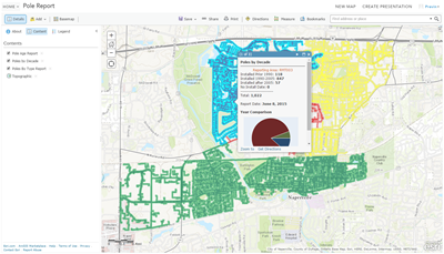
The Pole Reports solution includes the following reports:
- Poles by Decade
- Poles by Type
- Average Pole Age and Deprecation Cost
Requirements
Pole Reports requires specific technical experience and software.
| Requirement | Description |
| Software | Report Generation
Map service hosting
Application hosting
|
What you get
When you download Pole Reports, you'll find the following in the zip file:
| Directory | Item | Description |
| Application | A folder containing a set of Python 2.7 scripts to create and update the required services, maps, and apps in your organization. These scripts use the Automated Setup & Reporting tools. | |
| Maps and GDBs | AssetReports.gdb | A sample geodatabase with the pole reports schema and sample data. |
| ElectricNetwork.gdb | A sample geodatabase with electric network data summarized in the reports. | |
| GeographicBoundaries.gdb | A sample geodatabase with service area data used to summarize pole data for the reports. | |
| PoleReport.mxd | A map document used to publish the Pole Report feature service. | |
What's new
Below are the release dates and notes for Pole Reports.
| Date | Description |
| November 2020 |
|
| October 2019 |
|
| June 2017 |
|
| February 2016 |
|
| August 2015 |
|
| July 2015 |
|
| December 2014 |
|
| June 2014 |
|
Known issues
- The automated setup uses ArcREST, which does not support application and enterprise logins.
- When publishing to Portal for ArcGIS, the Hosting Server must use an ArcGIS Data Store as a managed geodatabase.
- When publishing to Portal for ArcGIS with an ArcGIS Data Store Hosting Server, field names will be auto converted to lowercase. The tools will update the maps created, but apps are not updated to handle this conversion.
- The script is delivered using relative paths. To use this without changing to absolute paths, you need to have python.exe as the default file extension for .py files and the path to Python in your systems path variable.