Overview
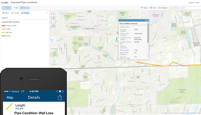
United States operators must inspect each individual pipeline or portion of pipeline exposed to the atmosphere for evidence of atmospheric corrosion at least every three years, with intervals not exceeding 39 months for onshore pipes. The Exposed Pipe Collector solution can be used to help meet this compliance requirement by allowing field crews to locate and inspect exposed pipes using a smartphone or tablet device in the field.
Using this solution and the ArcGIS Collector application allows field crews to collect exposed pipe locations and inspections regardless of connectivity to the office network, assuming cellular coverage is available.
Requirements
Exposed Pipe Collector requires specific technical experience and software.
| Requirement | Description |
| Software |
Solution deployment
Solution hosting
|
| Applications |
|
What you get
When you deploy Exposed Pipe Collector, you'll find the following:
| Item | Name | Description |
| Map | Exposed Pipe Collector | A map used by field technicians to record exposed pipe locations and conditions. |
| Feature layer | Exposed Pipe | A feature layer used to store the location of exposed pipes. |
What's new
Below are the release dates and notes for Exposed Pipe Collector.
| Date | Description |
| September 2020 |
|
| June 2017 |
|
| January 2017 |
|
| December 2014 |
|
| September 2013 |
|