Overview
Capital Improvement Planning can be used to plan and estimate the costs of capital projects.
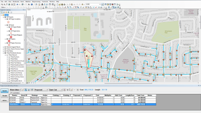
To accomplish these tasks, the map includes an interactive toolset to estimate project costs.
Requirements
Capital Improvement Planning requires specific technical experience and software.
| Requirement |
Description |
| Software |
Desktop
- ArcMap (Standard or Advanced) 10.2.1, 10.6 - 10.9
|
What you get
When you download the Capital Improvement Planning, you'll find the following in the zip file:
| Directory |
Item |
Description |
| Application
|
ArcGISCostEstimatingTools.esriAddIn
|
The Cost Estimating toolbar for estimating the costs of proposed capital improvement projects.
|
| MapsandGeodatabase
|
WaterUtilityCapitalPlanning.mxd
|
A map document used create and edit water, sewer, and stormwater capital improvement projects.
|
| CapitalImprovementPlanning.gdb
|
A sample geodatabase containing the datasets required for the ArcGISCostEstimatingTools add-in.
|
| WaterUtilities.gdb |
A sample geodatabase containing water, sewer, and stormwater networks for the City of Naperville, Illinois. To learn more about the schema of the WaterUtilities.gdb, see the data dictionary. |
| ReferenceData.gdb |
A sample geodatabase containing reference data for the City of Naperville, Illinois to support the capital project planning workflow. |
What's new
Below are the release dates and notes for Capital Improvement Planning.
| Date |
Description |
| November 2021 |
- Captial Improvement Planning has been moved to mature support.
|
| March 2019 |
- A resolution to a bug incorrectly requiring Project ID to be chosen before an asset could be selected.
- An enhancement where a tooltip shows the length of a line while it is being sketched.
- A resolution of a bug where features selected for costing were not honoring definition queries and all features were being loaded into the costing pane.
- A resolution to a bug where the project page was not loading details correctly the first time it was accessed.
|
| January 2018 |
- A resolution to a bug in which the Expected Start Date for a project could not be set for after December 31, 2029. (BUG-000103889)
- Support for ArcGIS 10.6.
|
| June 2017 |
- An update to the wAbandonedPoint and wAbandonedLine layers in the WaterUtilities.gdb. The POINTTYPE and LINETYPE fields were renamed to ABANSOURCE.
The LINETYPE field was also used in the wLateralLine class and the value in this field would be overwritten by the layer name when a feature was abandoned.
|
| March 2017 |
- The LocalGovernment.gdb has been removed and replaced with a series of geodatabases to support the capital improvement planning workflow.
- The inclusion of the WaterUtilities.gdb, which contains water, sewer, and stormwater data from the City of Naperville, Illinois. To learn more about the schema of the WaterUtilities.gdb, see the data dictionary.
- The inclusion of the CapitalImprovementPlanning.gdb, which contains the schemas required for the Capital Planning Add-In.
- The inclusion of the ReferenceData.gdb, which contains data in the editing basemap.
- An update to the water, sewer, and stormwater feature datasets to include a vertical coordinate system.
- The latest release of the Capital Planning Add-In, which includes the following:
- An enhancement to cost calculations to use geodetic length instead of shape length. (ENH-000100729)
- A resolution to a bug in which the Save Edits button would duplicate features when editing an existing project. The check box is now label and prompt on save. (BUG-000100682)
- A resolution to a bug where the Date Completed value was incorrectly being populated when the radio buttons were unchecked in the Project Cost Estimating Window. (BUG-000100689)
|
| June 2016 |
- The most recent Capital Planning Add-In
- The most recent LocalGovernment.gdb
|
| February 2016 |
- The most recent Capital Planning Add-In
- The most recent LocalGovernment.gdb
|
| July 2015 |
- The most recent Capital Planning Add-In
- The most recent LocalGovernment.gdb
- Removal of the Local Government toolbox
- New map document that no longer includes the Factors Used in Decision Support group layer, Field Notes layer, and Five Meter Surface raster
|
| December 2014 |
- The most recent Capital Planning Add-In
- The most recent Local Government toolbox
- The most recent LocalGovernment.gdb
|
| June 2014 |
- The most recent Local Government toolbox
- The most recent LocalGovernment.gdb
- The most recent Capital Planning Add-In
|
| December 2013 |
- The most recent LocalGovernment.gdb.
- The most recent Local Government toolbox.
|