This item has been moved to mature support. Please see What's new for more information.
Overview
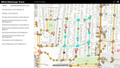
The Illicit Discharge Trace app allows the user to specify a location, such as the site of stormwater pollution, and trace the network upstream to find potential polluters.
This solution uses a custom widget in ArcGIS Web AppBuilder to run the upstream trace. To determine the potential polluters, information is passed to a geoprocessing service to run the analysis and process the results. The results are returned to the app, and the user can then export the results to a CSV.
Requirements
Illicit Discharge Trace requires specific technical experience and software.
| Requirement | Description |
| Software |
Map authoring
Map service hosting
Application hosting
|
| Applications |
|
What you get
When you download the Illicit Discharge Trace app, you'll find the following in the zip file:
| Directory | Item | Description |
| Application | NetworkTrace | A folder containing the Network Trace Web AppBuilder widget that can be configured to run the upstream trace. |
| Maps and GDBs | IllicitTrace.mxd | A map document used to publish the Upstream Trace geoprocessing service. |
| BusinessLocations.mxd | A map document used to publish the Business Locations feature service. | |
| PotentialBusinesses.mxd | A map document used to publish the Potential Businesses feature service to store the resulting businesses. | |
| IllicitDischargeTrace.gdb | A sample geodatabase with content from the City of Naperville, Illinois. | |
| IllicitTrace.tbx | A toolbox with a tool to trace upstream to find potential polluters. | |
| Icons | A folder containing icons for the services, maps, and apps. | |
What's new
Below are the release dates and notes for Illicit Discharge Trace.
| Date | Description |
| November 2020 |
|
February 2018 |
|
| January 2018 |
|
| June 2016 |
|
| February 2016 |
|
| October 2015 |
|
| July 2015 |
|
| June 2014 |
|