This item has been moved to mature support. Please see What's new for more information.
Overview
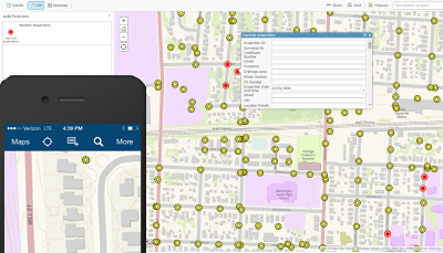
The Manhole Inspection solution modernizes the paper report workflow by using a map and inspection layer on a smartphone or tablet device. By using a map view of manholes, field crews are able to perform scheduled or ad hoc inspections on a mobile device using the manhole inspection schema.
Manhole Inspection is a configuration of ArcGIS. Once configured, the Manhole Inspection map can be accessed using the ArcGIS Collector app. With this, field crews can view manholes and add inspection records.
Requirements
Manhole Inspection requires specific technical experience and software.
| Requirement | Description |
| Software |
Map authoring
Map service hosting
|
| Applications |
|
What you get
When you download the Manhole Inspection map, you'll find the following in the zip file:
| Directory | Item | Description |
| Maps and GDBs | ManholeInspections.mxd | A map document used to publish the Manhole Inspection service. |
| ManholeInspections.gdb | A sample geodatabase with the manhole inspection schema and data for the City of Naperville, Illinois. | |
| Icons | A folder containing icons for the services, maps, and apps. | |
What's new
Below are the release dates and notes for Manhole Inspection.
| Date | Description |
| November 2020 |
|
| February 2015 |
|
| August 2014 |
|
| September 2014 |
|