Overview
Emergency Management Maps are used by emergency management and public safety staff to produce a standard set of maps used in briefing and response activities. Several of the incident-based map documents were developed using specifications from the GIS Standard Operating Procedures on Incidents (GSTOP) distributed by NWCG.
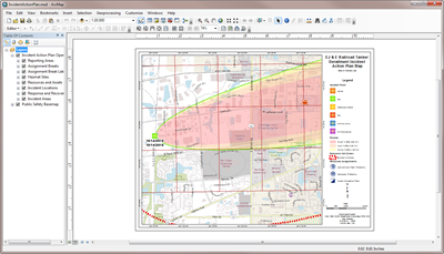
There are four map products included in this solution, Incident Action Plan, Incident Action Plan Map Book, Incident Briefing Map, and Hazard Map. The Incident Action Plan is an 8.5 by 11 inch map product that can be used to support operations and personnel and complements the Incident Action Plan Index Map. The Incident Action Plan Map Book is developed with Data Driven Pages and the 1 kilometer and 10 kilometer U.S. National Grid (USNG). The Incident Briefing Map is an ANSI E-sized map with details about the specific incident and the surrounding area. The Hazard Map displays the key natural and technological hazards. It's an example of a planning and analysis map and can be enhanced to better analyze the data to support additional planning and mitigation efforts.
Requirements
| Requirement | Description |
| Experience |
|
| Software | Map authoring
|
What you get
When you download the Emergency Management Maps map, the download includes the following:
| Directory | Item | Description |
| Application | FontsandStyles | A folder with TrueType fonts and style files used for symbolizing the points, lines, and polygons. |
| Output | A folder containing the final output IncidentActionPlanIndexMap.pdf. | |
| MapsandGeodatabase | HazardMap.mxd | A map document used to author the Hazard map. |
| IncidentActionPlan.mxd | A map document used to author the Incident Action Plan map. | |
| IncidentActionPlanDDP.mxd | A map document used to author the Incident Action Plan map book. | |
| IncidentActionPlanIndexMap.mxd | A map document used to author the Incident Action Plan Index map. | |
| IncidentBriefingMap.mxd | A map document used to author the Incident Briefing map. | |
| HazardMap.pdf | A sample Hazard map. | |
| IncidentActionPlan.pdf | A sample Incident Action Plan map. | |
| IncidentActionPlanIndexMap.pdf | A sample index map. | |
| IncidentActionPlanMapBook.pdf | A sample Incident Action Plan map book. | |
| IncidentBriefingMap.pdf | A sample Incident Briefing map. | |
| LocalGovernment.tbx | A toolbox with tools for constructing the Incident Action Plan map book. | |
| LocalGovernment.gdb | ArcGIS for Local Government geodatabase with content from the City of Naperville, Illinois. |
What's new
Below are the release dates and notes for Emergency Management Maps.
| Date | Description |
| June 2019 |
|
| June 2017 |
|
| December 2014 |
|
| June 2014 |
|
| December 2013 |
|
There is a newer version...
Emergency Management Maps (ArcMap configuration) has been retired and replaced with a new Emergency Management Maps (ArcGIS Pro configuration), upgrade to take advantage of newest version