This item has been moved to mature support. Please see What's new for more information.
Overview
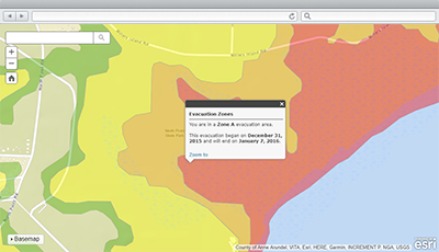
Evacuation Zones is a configuration of the Information Lookup application that can be used by emergency management staff to notify the public when evacuations are required.
Evacuation zones are typically referenced when people and property must be removed from a neighborhood or community because of safety concerns.
Requirements
To deploy Evacuation Zones with the ArcGIS Solutions Deployment Tool requires specific software.
| Requirement | Description |
| Software |
Solution deployment
Solution hosting
|
| Application |
|
What you get
Evacuation Zones can be deployed in your ArcGIS organization without downloading the solution. When you deploy Evacuation Zones in your organization, you'll find the following:
| Item | Name | Description |
| Application | Evacuation Zones | An application used by the emergency management staff to notify the public when evacuations are required. |
| Map | Evacuation Zones | A map used in the Evacuation Zones application to notify the public when evacuations are required. |
| Feature layer | EvacuationStatus | A feature layer used to store information about evacuation zones and routes. |
What's new
Below are the release dates and notes for Evacuation Zones.
| Date | Description |
| February 2020 |
|
| January 2017 |
|
| September 2016 |
|
| October 2014 |
|
There is a newer version...
Evacuation Zones has been moved to mature support and replaced with Public Information or Know Your Zone.