Overview
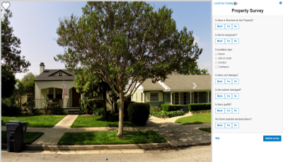

Photo Survey is a configuration of ArcGIS combined with a JavaScript application that can be used by emergency response organizations to publish aerial and street-level photo collections and conduct surveys that identify damaged areas and structures within the images.
Photo Survey expedites damage assessments by leveraging photos produced by many commercially available cameras. It combines these photos with a series of questions in the form of an online survey and associates the answers to points or administrative units on the ground.
The simple to use application will enable emergency operations staff, and optionally the general public, to review time sensitive images after a disaster, thus allowing emergency response organizations to quickly estimate damage costs and determine potential financial impacts of an event.
Requirements
Photo Survey requires specific software.
| Requirement | Description |
| Software |
Map authoring
GIS service hosting
Application hosting
|
| Browser compatibility |
The application is optimized for display on desktop computer, tablet, and smartphone devices using the following browsers:
|
What you get
When you download Photo Survey, you'll find the following files:
| Directory | Item | Description |
| Application | PhotoSurvey | A folder containing the Photo Survey application files. |
| SurveyConfigurations | A folder containing sample property survey questions. | |
| PhotoSurvey.tbx | A toolbox with a tool used to import photo collections and publish property surveys. |
What's new
Below are the release dates and notes for Photo Survey.
| Date | Description |
| June 2019 |
|
| December 2017 |
|
| December 2016 |
|
| June 2016 |
|
| October 2015 |
|
There is a newer version...
This version of the Photo Survey application has been retired and replaced with a new Photo Survey, upgrade to take advantage of newest version