Overview
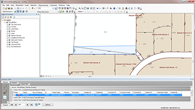
Data Reviewer for Tax Parcels provides preconfigured ArcGIS Data Reviewer for Desktop batch jobs (.rbj) that can be used to validate, maintain, and improve the integrity of parcel data.
Data Reviewer provides a set of tools to simplify many aspects of automated and visual data quality control. Data Reviewer provides over 40 out-of-the-box checks that can be run individually, grouped into batch jobs (.rbj files), or run as a scheduled service. The batch jobs provided with Data Reviewer for Tax Parcels are configured to work with the Local Government Information Model.
Requirements
Data Reviewer for Tax Parcels requires specific software.
Before downloading Data Reviewer for Tax Parcels, ensure Tax Parcel Editing has also been downloaded.
| Requirements | Description |
| Software |
Map authoring
|
What you get
When you download the Data Reviewer for Tax Parcels, you'll find the following files:
| Directory | Item | Description |
| Application | 10.4 | A folder containing ArcGIS 10.4 Data Reviewer batch job file with preconfigured checks for performing quality control on parcel and parcel fabric data. |
| 10.5 | A folder containing ArcGIS 10.5 Data Reviewer batch job file with preconfigured checks for performing quality control on parcel and parcel fabric data. | |
| 10.6 | A folder containing ArcGIS 10.6 Data Reviewer batch job file with preconfigured checks for performing quality control on parcel and parcel fabric data. | |
| 10.7 | A folder containing ArcGIS 10.7 Data Reviewer batch job file with preconfigured checks for performing quality control on parcel and parcel fabric data. | |
| MapsandGeodatabase | TaxParcelPreparationMap.mxd | A map document used to validate sample parcel data. |
| DataReviewer.gdb | A sample Reviewer workspace used to store error results. | |
| LandRecordsStaging.gdb | A sample staging geodatabase with content from the City of Naperville, Illinois. | |
| DataReviewerforTaxParcels.tbx | A toolbox with a model used to identify lots that are not within a subdivision. |
What's new
Below are the release dates and notes for Data Reviewer for Tax Parcels.
| Date | Description |
| February 2020 |
|
| September 2016 |
|
| July 2015 |
|
| December 2014 |
|
| June 2014 |
|