Overview

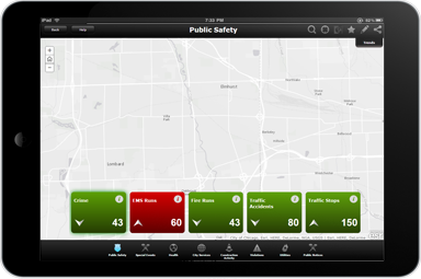
Executive Dashboard is a configuration of ArcGIS Online and a JavaScript application used by local government leaders to proactively view critical metrics, identify trends, raise questions, and devise new management strategies. The Dashboard is a single application that can be deployed by local governments and used by decision-makers on a tablet device and desktop computer.
The Executive Dashboard offers a map-based view of key performance indicators (KPIs) that decision-makers and senior management need to effectively run an organization. It aggregates information from multiple sources and serves as a starting point from which the executive can get a sense of the big picture before digging deeper into data. The Dashboard can be used to view performance across an entire community, or in a specific neighborhood you are interested in.
Requirements
Executive Dashboard requires specific technical experience and software.
| Requirement | Description |
| Experience |
|
| Software |
Map authoring
GIS service hosting
Application hosting
|
| Browser compatibility |
The application is optimized for display on desktop computers and tablet devices using the following browsers:
|
What you get
When you download the Executive Dashboard, you'll find the following files:
| Directory | Item | Description |
| Application | ExecutiveDashboard | A folder containing the Executive Dashboard application files. |
| ExecutiveReportingScript | A folder containing scripts used to configure and schedule the creation of executive reporting layers. | |
| MapsandGeodatabase | PerformanceIndicators.mxd | A map document used to publish the PerformanceIndicators service. |
| LocalGovernment.gdb | ArcGIS for Local Government geodatabase with content from the City of Naperville, Illinois. |
What's new
Below are the release dates and notes for Executive Dashboard.
| Date | Description |
| January 2017 | Executive Dashboard has been moved to mature support. |
| September 2016 |
|
| June 2016 |
|
| July 2015 |
|
| December 2014 |
|
| June 2014 |
|
| November 2013 |
|
You may be interested in
ArcGIS for Local Government includes several related maps and apps that also can be configured in your organization: