ArcGIS Web AppBuilder application consumes maps that are accessible to the general public and named users in your ArcGIS organization. Create a Site Selector map and share it with citizens you serve. They can then access the application on their smartphone, tablets, and desktop computers.
Site Selector map
To create an Site Selector map, complete the following steps:
- Sign in to your ArcGIS organization.
- Create a map to display available buildings and sites, by completing the following workflow:
- Choose a basemap.
- Add the DevelopmentSites_public layer to the map. Rename the DevelopmentSites_public - Improved Sites layer to Improved Sites and DevelopmentSites_public - Vacant Sites to Vacant Sites.
- Configure the Improved Sites pop-up using the custom attribute displayed option and use the Name field as the pop-up title. When configuring the pop-up, click View HTML Source and add the following code, and then click OK.
<font face="Avenir-Light">{fulladdr} <br /> {municipality}, {pocstate}, {sitezip} <br /><br /><b> Description</b> <br /><br /> {descript} <br /><br /><b> Site Information</b><br /><br />Current Zoning: {zonedesc} <br />Building Floor Area: {bldgarea} sq. ft. <br /><br /> Distance to Highway: {disthgwy} mi. <br />Distance to Rail: {distrail} mi. <br />Distance to Airport: {distair} mi. <br /><br /> Gas Service: {gas} <br />Electric Service: {electric} <br />Broadband Service: {isp} <br />Water Service: {water} <br />Sewer Service: {sewer} <br /><br /><b> Contact Information</b> <br /><br /> {pocname}<br /> {pocphone} <br /><a href="mailto:{pocemail}" target="_blank">{pocemail}</a></font>{fulladdr} <br /> {municipality}, {pocstate}, {sitezip} <br /><br /><b> Description<br /> <br /><br/> {descript}<br /><br/><b> Site Details:</b><br /><br />Current Zoning: {zonedesc} <br />Size: {minarea} to {maxarea} ac. <br />Total Area: {totarea} ac. <br /> <br /> Distance to Highway: {disthgwy} mi. <br />Distance to Rail: {distrail} mi. <br />Distance to Airport: {distair} mi. <br /><br /> Gas Service: {gas} <br />Electric Service: {electric} <br />Broadband Service: {isp} <br />Water Service: {water} <br />Sewer Service: {sewer} <br /><br /><b> Contact Information</b> <br /> {pocname}<br /> {pocphone} <br /><a href="mailto:{pocemail}" target="_blank">{pocemail}</a>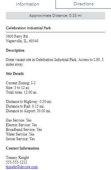
An example of a pop-up configuration for the Vacant Sites layer in the Site Selector application. - Save the map as Site Selector add the following tags and enter a summary:
- Tags: Development Sites, Vacant Land, Site Selector, Economic Development.
- Summary: A map used in the Site Selector application to review available buildings and sites.
- Save the map and share it with everyone.
- Browse to the map and edit the item details:
- Thumbnail image: Your image.
- Description: A map used in the Site Selector application to review available buildings and sites.
- Set map options by disabling the Measure Tool and Basemap Selector.