Overview
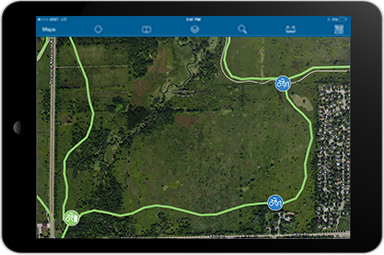
Cycling Infrastructure Inventory can be used to inventory bikeways (lanes, paths, and routes), bike parking, and bike share stations.
The Cycling Infrastructure Inventory map helps transportation staff develop a comprehensive inventory of cycling infrastructure; and prepare this information for related maintenance management workflows.
Requirements
To deploy Cycling Infrastructure Inventory with the ArcGIS Solutions Deployment Tool requires specific software.
| Requirement | Description |
| Software |
Solution deployment
Solution hosting
|
| Applications |
|
To manually deploy Cycling Infrastructure Inventory in your organization requires specific software.
| Requirement | Description |
| Software |
Map authoring
GIS service hosting
|
| Applications |
|
What you get
Cycling Infrastructure Inventory can be deployed in your ArcGIS organization without downloading the solution. When you deploy Cycling Infrastructure Inventory in your organization, you'll find the following:
| Item | Name | Description |
| Map | Cycling Infrastructure Inventory | A map used by field staff to inventory cycling infrastructure including bikeways (lanes, paths, and routes), bike parking, and bike share stations. |
| Feature layer | CyclingInfrastructure | A feature layer used to store bikeways, bike parking, and bike sharing stations. |
What's new
Below are the release dates and notes for Cycling Infrastructure Inventory.
| Date | Description |
| November 2023 |
|
| September 2018 |
|