Overview
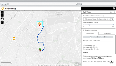
Early Voting is a configuration of ArcGIS Web AppBuilder that can be used by citizens to locate the nearest voting centers where ballots can be cast in person or by mail. This application can be accessed from a smartphone, tablet, and desktop computer.
An early voting location allows participation by voters who may not be able to vote on the set election day or days. The availability and time periods for early voting vary by jurisdiction and is presented to users when they find a location near their home or place of business.
Requirements
To deploy Early Voting with the ArcGIS Solutions Deployment Tool requires specific software.
| Requirement | Description |
| Software |
Solution deployment
Solution hosting
|
| Application |
|
To manually deploy Early Voting in your organization requires specific software.
| Requirement | Description |
| Software |
Map authoring
GIS service hosting
|
| Application |
|
What you get
Early Voting can be deployed in your ArcGIS organization without downloading the solution. When you deploy Early Voting in your organization, you'll find the following:
| Item | Name | Description |
| Application | Early Voting | An application used by citizens to locate the nearest voting center where ballots may be cast in person or by mail. |
| Map | Early Voting | A map used in the Early Voting application to locate the nearest voting center. |
| Feature layer | EarlyVotingLocations | A feature layer used to store locations where ballots can be cast in person or by mail prior to election day. |
What's new
Below are the release dates and notes for Early Voting.
| Date | Description |
| March 2019 |
|
| March 2017 |
|
| January 2017 |
|
| December 2016 |
|
| September 2016 |
|
| June 2016 |
|
| February 2016 |
|
| October 2015 |
|