Overview
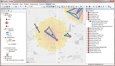
Repeat and Near Repeat Analysis is a configuration of ArcGIS Desktop that can be used by law enforcement agencies to identify repeat and near repeat victimization patterns of a particular crime type within a specified time frame and geographic area. As patterns are identified, prediction zones can be created and used for crime mitigation activities.
Repeat and Near Repeat Analysis leverages extensive research on predictive mapping theory in the law enforcement community and incorporates these theories in to a Crime Analysis toolbox that supports predictive policing efforts across an entire community.
Requirements
Repeat and Near Repeat Analysis require specific software.
| Requirement | Description |
| Software |
Map authoring
GIS service hosting (optional)
|
What you get
When you download Repeat and Near Repeat Analysis, you'll find the following files:
| Directory | Item | Description |
| MapsandGeodatabase | Output | A folder containing near repeat summary files. |
| CrimeAnalysisTools | A toolbox containing the Repeat and Near Repeat toolset. | |
| Burglaries.mxd | A map document containing example burglary data. | |
| Burglaries.aprx | An ArcGIS Pro project containing example burglary data in 2D and 3D views. | |
| CrimeAnalysis.gdb | A sample geodatabase with example crime analysis layers. |
What's new
Below are the release dates and notes for Repeat and Near Repeat Analysis.
| Date | Description |
| June 2019 |
|
| September 2018 |
|
There is a newer version...
Repeat and Near Repeat Analysis has been moved to mature support and replaced with new capabilities in the Crime Analysis solution.