This item has been moved to mature support. Please see What's new for more information.

Overview

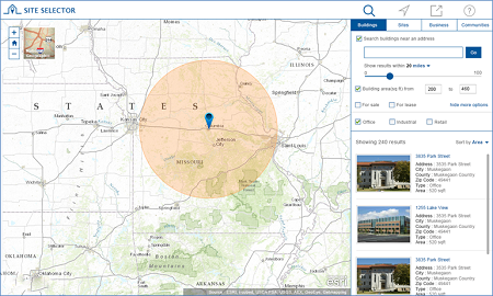
Site Selector is a configuration of ArcGIS and a JavaScript application that helps business owners and corporations locate available buildings and sites, and combine their property search with key community and business demographic information. It is a single application that can be deployed by government agencies and accessed by business owners and corporations on desktop computers and tablet devices.

The real estate information, demographic analysis, and reports provided in the Site Selector application facilitates better business decisions. It also helps to ensure that business investments made in the community are sustainable and align with their corporate vision.

Requirements

Site Selector requires specific software.

Requirement Description
Software
Map authoring
GIS service hosting
  • ArcGIS Online, and
  • ArcGIS 10.4 for Server (Standard or Advanced), or
  • ArcGIS Enterprise 10.5 - 10.6 (Standard or Advanced)
  • ReportLab 3.0 for Python 64-bit (Reportlab-3.0.win-amd64-py2.7.exe)
  • Pillow 2.6 for Python 2.7 64-bit (Pillow-2.6.0.win-amd64-py2.7.exe)
Application hosting
  • Microsoft Internet Information Services (IIS) 7.0 or higher
  • Microsoft ASP.NET Framework 4.0 or 4.5
Browser compatibility

The application is optimized for display on desktop computer, tablet, and smartphone devices using the following browsers:

  • Microsoft Internet Explorer 10, 11
  • Mozilla Firefox
  • Google Chrome
  • Apple Safari

What you get

When you download the Site Selector application, the download includes the following:

Directory Item Description
Application SiteSelector A folder containing the Site Selector application files.
MapsandGeodatabase SiteSelector.mxd A map document used to publish the SiteSelector service.
SiteSelector.tbx A toolbox with a tool used to produce the development sites PDF reports.
StateGovernment.gdb State Government geodatabase with sample data.

What's new

Below are the release dates and notes for Site Selector.

Date Description
January 2017
  • The Site Selector application has moved to mature support.
October 2016
  • An update to the application configuration to resolve an issue with the geometry service that was causing the message "The searched area is outside the area of interest and will not be analyzed" to display incorrectly.
June 2016
  • Added support for PDF and other attachment types.
  • Added support for using Site Selector on smartphone devices.
  • An enhancement to the application that now updates the map to reflect search and filter results.
  • An update to the application to use a new approach to authenticating with the GeoEnrichment service in the application proxy.
  • An enhancement to the application so that its download menu now automatically expands to display all available reports.
  • A fix to a bug that had prevented community information from displaying for communities with a space or apostrophe in the name when the application is shared.
  • An update to the application's configuration file to hide the locate button by default.
July 2015
  • Improved localization support.
  • Added support for custom map pop-ups and made a series of user interface improvements in Site Selector pop-up display.
  • A resolution to a bug that caused community layers to be queried unnecessarily.
  • A resolution to a bug that displayed incorrect basemap references.
  • An enhancement that adds support for multiple filters on the same field in a layer.
  • A resolution to a bug that prevented non-String based fields with Null values to be displayed in the user interface.
  • An enhancement that improves application state when sharing content from the application.
  • An enhancement that simplifies the application configuration by using map layer names instead of service names.
  • A series of user interface improvements in the search, filter, and report panels.
  • An enhancement that improves the user experience when filtering content and clearing results.
  • A resolution to a bug that prevented property and neighborhood Information from being accessible in a single panel.
February 2015
  • First release of the Site Selector application

Get started with Site Selector

You may be interested in

ArcGIS Solutions for State Government includes several related maps and apps that also can be configured in your organization:

Top