This item has been moved to mature support. Please see What's new for more information.
Overview
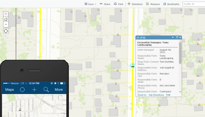
Despite call before you dig programs, gas utilities face the challenge of dealing with damages to assets during excavation. These excavation damages must be recorded for any on the gas distribution network. The Excavation Damage Collector can be used in the ArcGIS Collector application by field crews to collect excavation damage locations, information, and photos of the damage. This map can be updated regardless of connectivity to the office network assuming cellular coverage is available or offline editing is enabled.
Requirements
Excavation Damages requires specific technical experience and software.
| Requirement | Description |
| Software |
Solution deployment
Solution hosting
|
| Applications |
|
What you get
When you deploy Excavation Damages, you'll find the following:
| Item | Name | Description |
| Map | Excavation Damages | A map used by field technicians to record excavation damages. |
| Feature layer | Excavation Damage | A feature layer used to store the location of excavation damages. |
What's new
Below are the release dates and notes for Excavation Damages Collector.
| Date | Description |
| November 2020 |
|
| June 2017 |
|
| January 2017 |
|
| December 2014 |
|
| June 2014 |
|