Overview
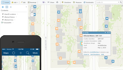
In the event of a gas outage, a gas utility must have field crews relight any shut off gas meters. The Gas Relight solution provides a map based view of affected meters, which can be updated by field crews throughout the relight process to reflect a meter's status.
The Gas Relight solution is a configuration of ArcGIS and the ArcGIS Collector application. This allows field crews to change the relight status of gas meters regardless of connectivity to the office network. This map can be used in the field assuming cellular coverage is available or offline editing is enabled.
Requirements
Gas Relight requires specific technical experience and software.
| Requirement | Description |
| Software |
Solution deployment
Solution hosting
|
| Applications |
|
What you get
When you deploy Gas Relight, you'll find the following:
| Item | Name | Description |
| Map | Gas Relight | A map used by field crews to update the status of meters and valves during the relight process. |
| Feature layer | Gas Relight | A feature layer used to store the location of customers needing relights. |
What's new
Below are the release dates and notes for Gas Relight.
| Date | Description |
| November 2020 |
|
| June 2017 |
|
| January 2017 |
|
| June 2014 |
|