This item has been moved to mature support. Please see What's new for more information.
Overview
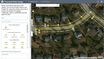
The Proposed Water Design solution can be used by water engineers and developers to quickly sketch in proposed or early stage water infrastructure projects using ArcGIS Web AppBuilder. To simplify the sketching process, the designer selects valid sketch types from a predefined list.
The designs created in the Proposed Water Design app can then be shared with the utility's ArcGIS organization to increase collaboration on early stage or proposed projects.
Requirements
Proposed Water Design requires specific technical experience and software.
| Requirement | Description |
| Software |
Solution deployment
Solution hosting
|
| Applications |
|
What you get
When you deploy Proposed Water Design, you'll find the following:
| Item | Name | Description |
| Application | Proposed Water Design | An application used by water engineers to sketch proposed or early stage water infrastructure designs. |
| Map | Proposed Water Design | A map used by water engineers to sketch proposed or early stage designs. |
| Feature layer | Proposed Water Design | A feature layer used to store infrastructure designs submitted by engineers or developers. |
What's new
Below are the release dates and notes for Proposed Water Design.
| Date | Description |
| November 2020 |
|
| June 2017 |
|
| January 2017 |
|
| September 2016 |
|
| March 2015 |
|
| February 2014 |
|