Overview
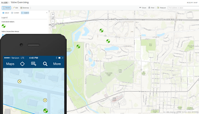
The Valve Exercising solution modernizes the paper report for valve inspection and exercising information by using a map and exercising layer on a smartphone or tablet device. By using a map view of system valves, field crews are able to record valve exercising activities using the valve exercising schema.
Valve Exercising is a configuration of ArcGIS. Once deployed, field crews can access the Valve Exercising map using the ArcGIS Collector application. This allows field crews to collect information regardless of connectivity to the office network assuming cellular coverage is available.
Requirements
Valve Exercising requires specific technical experience and software.
| Requirement | Description |
| Software |
Map authoring
Map service hosting
|
| Applications |
|
What you get
When you download the Valve Exercising map, you'll find the following in the zip file:
| Directory | Item | Description |
| Maps and GDBs | ValveExercising.mxd | A map document used to publish the Valve Exercising service. |
| ValveExercising.gdb | A sample geodatabase with the valve inspection/exercising schema and sample system valves for the City of Naperville, Illinois. | |
| Icons | A folder containing icons for the services, maps, and apps. | |
What's new
Below are the release dates and notes for Valve Exercising.
| Date | Description |
| November 2020 |
|
| February 2015 |
|
| July 2013 |
|