The ArcGIS Solutions website will no longer be available after September 1, 2025. See the latest documentation.
This item is now in mature support. Military Overlay solution functionality is now found on the ArcGIS Solutions for Defense site. For more information about mature support, please visit the Esri Product Life Cycle page.
Overview
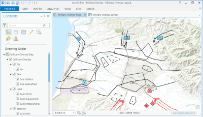
Military Overlay can be used to create overlays with standard military symbols, by using and adapting existing feature templates.
The Military Overlay is supplied as a project template for ArcGIS Pro. The Military Overlay is a solution for creating and sharing military overlays. It allows you to:
- Create military standard symbols quickly by using and adapting existing feature templates.
- Create a military overlay with military standard symbols.
- Share the overlay as either a static image or a web map.
Requirements
Military Overlay requires specific technical experience and software. Minimum system requirements for the ArcGIS Platform can be found on the Support website.
| Requirement | Description |
| Software |
Map Authoring
GIS Service Hosting
|
What you get
When you download Military Overlay, the download includes the following:
| File | Folder | Description |
| MilitaryOverlay.zip | ArcGIS Pro | Folder containing an ArcGIS Pro project template and schema-only layer packages to get you started with Military Overlay workflows. |
| Resources | Supporting files for Military Overlay. |
What's new
Below are the release notes for Military Overlay. If you need support, please contact Esri Support Services. If you'd like to get help from other military and intelligence community members, post your question on GeoNet.
| Date | Description |
| September 2017 |
|
| June 2017 |
|
| 1.2.0 |
|
| 1.1.1 |
|
| 1.1.0 with 2525B Change 2 |
|
| 1.1.0 |
|
| 1.0.1 |
|
| 1.0.0 |
|