Overview
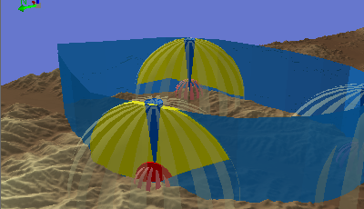

The Range Dome Analysis template allows you to analyze threats to flight corridors in 3D space. Range domes are used to model volumetric spaces that are within a direct 3D distance of a key point or installation, such as a viewing platform, radar station, or anti-aircraft weapon. Range domes are commonly used to evaluate the threat levels within a 3D corridor passing through, or near, a number of key locations. This template takes into account multiple site locations, multiple planned corridors, two range dome distances, and the impact of the surrounding terrain on the line-of-sight.
This template allows you to:
- Digitize viewpoints/threat locations
- Digitize proposed corridor routes
- Generate volumetric threat zones within the proposed corridors
Requirements
Range Dome Analysis requires specific technical experience and software. Minimum system requirements for the ArcGIS Platform can be found on the Support website.
Range Dome Analysis is supported on ArcGIS 10.2.2, 10.3, and ArcGIS Pro 1.3.
| Requirement | Description |
| Experience |
|
| Software |
Map Authoring
|
What you get
When you download the Range Dome Analysis template it comes as a ArcGIS Pro project template. This project includes the following:
| Folder | Item | Description |
| Project template and GDBs | RangeDomeAnalysis | Pro project with sample layers for range dome flight corridor threat analysis. |
| RangeDomeAnalysis.gdb | File Geodatabase with data and schema for input and output layers for range dome flight corridor threat analysis. | |
| RangeDomeTools.tbx | Toolbox with a model tool for range dome flight corridor threat analysis. | |
| OUTPUT - Flight Corridor Dangerous.lyr | A layer with symbology for dangerous areas of flight corridors. | |
| OUTPUT - Flight Corridor Lethal.lyr | A layer with symbology for lethal areas of flight corridors. | |
| Elevation.lyr | A layer with symbology for an elevation raster. | |
| CorridorBuffer.lyr | A layer with symbology for a buffer zone around a flight corridor. | |
| Friendly Ops Line - Air corridor.lpk | A layer package with a schema and sample data for lines that indicate air corridors for friendly forces. | |
| Friendly Ops Line - Draped.lpk | A layer package with a schema and sample data for lines draped on a terrain surface that indicate air corridors for friendly forces. | Range Domes.lpk | A layer package with a schema and sample data for range domes. |
| Threat Positions.lpk | A layer package with a schema and sample data for known anti-aircraft threat positions. | |
| Extrude_WorldY_RangeAttr.rpk | A CityEngine rule package for generating 3D features with the Features from CityEngine Rules geoprocessing tool in the Range Dome Corridor model tool. CityEngine does not need to installed for the tool to work. | |
| zRangeDomeAnalysis_Local.zip | Zip archive containing an empty template for you to use with your own data for range dome flight corridor threat analysis. |
What's new
Below are the release notes for Range Dome Analysis. If you need support, please contact Esri Support Services. If you'd like to get help from other military and intelligence community members, post your question on GeoNet.
| Version | Description |
| 3.0.0 |
|
| 2.0.0 |
|
| 1.0.0 |
|
Known Issues
- When using the ArcGIS Pro Project Template a user must unzip the RPK folder to the root folder of the project or the template will not run. This zip can be found in the common data folder of the project. There is also a tool in the template that will make this extraction
- The analysis may fail for high-resolution elevation data. See the Troubleshooting section for tips on resolving the issue.
- The analysis may fail for one (or a few) items only. See the Troubleshooting section for tips on resolving the issue.
You may be interested in
... related solutions that can be configured for your organization: