This item has been moved to mature support. Please see What's new for more information.
Overview
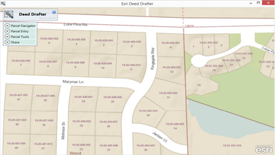
Deed Drafter is a configuration of ArcGIS and a Runtime application that helps mapping technicians enter metes-and-bounds descriptions from deeds and recorded documents and check for closure errors.
Deed Drafter is typically used by Assessors Offices, Register Of Deeds Offices, private surveyors, title companies, and other similar organizations.
Requirements
Deed Drafter requires specific technical experience and software.
| Requirement | Description |
| Experience |
|
| Software |
Map authoring
GIS service hosting
Application hosting
|
What you get
When you download the Deed Drafter, you'll find the following files:
| Directory | Item | Description |
| Application | Deed Drafter | A folder containing the application files, graphics, and items needed to configure the Deed Drafter application. |
| MIXED90CacheSettings.xml | A tiling scheme suitable for the Tax Parcel basemap. | |
| MapsandGeodatabase | TaxParcel.mxd | A map document used to publish the Tax Parcel tiled or cached service. |
| TaxParcelQuery.mxd | A map document used to publish the TaxParcelQuery service. | |
| LocalGovernment.gdb | ArcGIS for Local Government geodatabase with content from the City of Naperville, Illinois. |
What's new
Below are the release dates and notes for Deed Drafter.
| Date | Description |
| September 2016 |
|
| June 2016 |
|
| October 2015 |
|
| June 2014 |
|
| August 2013 |
|
There is a newer version...
The Deed Drafter application has been moved to mature support and replaced with a new Parcel Drafter application that leverages ArcGIS Online and ArcGIS Web AppBuilder, upgrade to take advantage of newest version