Overview
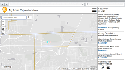
My Elected Representative is a configuration of the Information Lookup application that can be used by citizens to determine who represents them in local, state, and federal elected offices. This application can be accessed from a smartphone, tablet, and desktop computer.
Organizations can deploy a single application that includes local, state and federal representatives; or deploy multiple applications (for example, My Local Representative, My Legislative Representative) that only include representatives from one or more levels of government.
Requirements
To deploy My Elected Representative with the ArcGIS Solutions Deployment Tool requires specific software.
| Requirement | Description |
| Software |
Solution deployment
Solution hosting
|
| Application |
|
To manually deploy My Elected Representative in your organization requires specific software.
| Requirement | Description |
| Software |
Map authoring
GIS service hosting
|
| Application |
|
What you get
My Elected Representative can be deployed in your ArcGIS organization without downloading the solution. When you deploy My Elected Representative in your organization, you'll find the following:
| Item | Name | Description |
| Application | My Elected Representative | An application used by citizens to determine who represents them in local, state, and federal elected offices. |
| Map | My Elected Representative | A map used in the My Elected Representative application to determine who represents them in local, state, and federal elected offices. |
| Feature layer | ElectoralDistricts | A feature layer used to store territorial subdivisions for electing members to a legislative body along with precinct and polling places. |
What's New
Below are the release dates and notes for My Elected Representative.
| Date | Description |
| March 2019 |
|
| January 2017 |
|
| June 2016 |
|
| October 2015 |
|