Overview
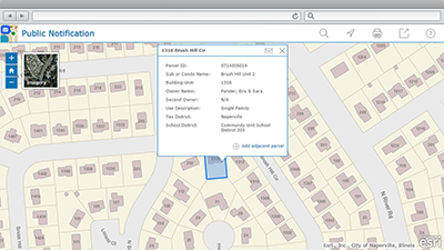
Public Notification is a configuration of ArcGIS and a JavaScript application that allows local government staff to identify a collection of properties and create mailing labels, or a structured text file, of owners and occupants. This application is typically used by planning and zoning officials, but it can be used by any agency looking to notify property owners or occupants of a formal action being taken.
A collection of properties to be notified can be generated by specifying a distance from a property boundary (buffer); selecting properties along an adjoining roadway; identifying properties within an administrative area; or drawing a specific area and identifying properties within the newly drawn area.
The responsibility for distributing public notices varies by local government. In some cases, the petitioner or applicant may be responsible for distributing the notices. In others, the local government itself will distribute the notices to surrounding property owners. In either case, Public Notification creates a list of property owners or occupants to be notified and an accompanying map that illustrates who was notified.
Requirements
Public Notification requires specific software.
| Requirement | Description |
| Software |
Map authoring
GIS service hosting
Application hosting
|
| Browser compatibility | The application is optimized for display on desktop computers using the following browsers:
|
What you get
When you download the Public Notification, you'll find the following files:
| Directory | Item | Description |
| Application | PublicNotification | A folder containing the Public Notification application files. |
| MIXED90CacheSettings.xml | A tiling scheme suitable for the General Purpose and other basemaps. | |
| MapsandGeodatabase | AdministrativeAreas.mxd | A map document used to publish the AdministrativeAreas service. |
| GeneralPurpose.mxd | A map document used to publish the General Purpose tiled or cached service. | |
| RoadCenterlineQuery.mxd | A map document used to publish the RoadCenterlineQuery service. | |
| ImageryReferenceOverlay.mxd | A map document used to publish the Imagery Reference Overlay tiled or cached service. | |
| TaxParcelQuery.mxd | A map document used to publish the TaxParcelQuery service. | |
| LocalGovernment.tbx | A toolbox with tools used to produce the mailing labels and CSV file of addresses. | |
| LocalGovernment.gdb | ArcGIS for Local Government geodatabase with content from the City of Naperville, Illinois. |
What's new
Below are the release dates and notes for Public Notification.
| Date | Description |
| January 2018 |
|
| March 2017 |
|
| June 2016 |
|
| February 2016 |
|
| July 2015 |
|
| December 2014 |
|
| June 2014 |
|
| November 2013 |
|
| 10.2 |
|
| November 2012 |
|
You may be interested in
ArcGIS for Local Government includes several related maps and apps that also can be configured in your organization: