The Point of Sale app requires the Service Feasibility widget, which is used to find a route, estimate the cost, and save the results to a feature service. To configure this app, you will need to install and deploy the widget using the Web AppBuilder (Developer Edition).
Service Feasibility widget
Before configuring the app, you will need to add the Service Feasibility widget to your Web AppBuilder (Developer Edition). To deploy the widget, complete the following steps:
- In Windows Explorer, browse to the download's Applications folder.
- Deploy the Service Feasibility widget.
- Start Web AppBuilder (Developer Edition). You will now be able to configure an application using the Service Feasibility widget.
Point of Sale app
- Create a new app with the following settings:
- Name: Point of Sale
- Description: The Point of Sale application can be used by sales staff to quickly determine shortest route, discover services available, estimate the cost of service, and save the results.
- Update the app's theme and other general settings to your preferences.
- Update the map by select the Point of Sale map.
- Add a new Service Feasibility widget.
-
Configure a new Service Feasibility widget with the following settings:
Parameter Settings Closest facility parameters Closest facility service URL: ArcGIS Online Closest Facility service proxy
Facility search distance: 20,000
Impedance attribute: Miles
Default cut off distance: 50,000
Use travel modes: Walking Distance
Custom attribute parameter values: If not using travel modes, configure the attribute parameters for the closest facility task. For each parameter, default to value and update the value if needed.
Attribute lookup Attribute parameter value lookup: Prohibited, Avoid_High, Avoid_Medium, Avoid_Low, Prefer_Low, Prefer_Medium, Prefer_High
Selection layer settings Enable selection layer: Unchecked
Route settings Access point layers: Check Splice Closure and Patch Panel. Uncheck Allow user to select Access Point layer
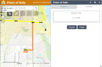
Route result label: Route Cost
Route result expression: {Length} * 4. Alternatively, create an equation using the length and the cost of fiber per meter in your organization.
Route result unit label: $
Result unit label position: Before
Rounding Option: no decimal
Target layers to save results to layer Route layer: Cable Fiber (Project Planning Markup)
- Field to save route length : ROUTELEN
- Field to save route result expression: ROUTECOST
Export to CSV Export to CSV: Unchecked
Barrier symbols Allow barriers: Checked
Point barrier symbol: Select a symbol
Line barrier symbol: Select a symbol
Polygon barrier symbol: Select a symbol
Location symbol Select a symbol
Route symbol Select a symbol
Buffer symbol Select a symbol
Highlighter image Image: Select an image or leave as default
Height: 100
Width: 100
Timeout: 1000
- Update the app's attributes to meet your organization's needs and branding.
- Save the application.
-
Deploy the app and register the app to your ArcGIS Online organization.
- Title: Point of Sale
- Thumbnail image:
- Summary: Application to find and cost the optimal route for fiber to a new location.
- Description: The Point of Sale application can be used by sales staff to quickly determine services available, optimal route for service, and the estimated cost of the service. Once the route is found, the results can be saved to a feature service to be able to use in other applications.
- Tags: Telecommunications, Fiber, Sales, Cost