The ArcGIS Solutions website will no longer be available after September 1, 2025. See the latest documentation.
This item has been moved to mature support. Please see What's new for more information.
Overview
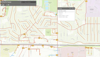
Schneider Electric's ArcFM Feeder map provides an overview of the electric network with conductors thematically mapped by feeder ID. This solution provides planning, operations, and contractors with a map showing the locations of substations, circuit breakers, open tie points, switchable devices, primary overheads, and underground conductors.
ArcFM Feeder map enables organizations to view the electric network on a browser, desktop, or mobile device.
Requirements
ArcFM Feeder map requires specific technical experience and software.
| Requirement | Description |
| Software |
Data Publishing
GIS Service Hosting
Map and App Authoring
|
| Applications |
Web Template
ArcGIS 10.2 |
What you get
When you download ArcFM Feeder map, you'll find the following in the .zip file:
| Directory | Item | Description |
| Maps and GDBs | ArcFM_Feeder.mxd | A map document used to publish the ArcFM Feeder service. |
| ArcFM_Feeder.gdb | A sample ArcFM geodatabase with sample electric feeder data. | |
| Icons | A folder containing icons for the services, maps, and apps. | |
What's new
Below are the release dates and notes for ArcFM Feeder map.
| Date | Description |
| November 2020 |
|
| January 2018 |
|
| September 2016 |
|
| March 2015 |
|
| June 2014 |
|