Overview
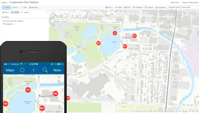
The Stormwater Construction Site Violations solution allows field staff to record stormwater construction site violations using a mobile device.
Stormwater Construction Site Violations is a configuration of ArcGIS. Once configured, the Stormwater Construction Site Violations map can be accessed by field crews using the ArcGIS Collector application. This allows field staff to input the type of violation and attach photos as needed regardless of connectivity to the office network, assuming cellular coverage is available.
Requirements
Stormwater Construction Site Violations requires specific technical experience and software.
| Requirement | Description |
| Software |
Solution deployment
Solution hosting
|
| Applications |
|
What you get
When you deploy Stormwater Construction Site Violations, you'll find the following:
| Item | Name | Description |
| Map | Stormwater Construction Site Violation | A map used by field technicians to record stormwater construction site violation. |
| Feature layer | Stormwater Construction Site Violation | A feature layer used to store the location construction site stormwater violations. |
What's new
Below are the release dates and notes for Stormwater Construction Site Violations.
| Date | Description |
| November 2020 |
|
| June 2017 |
|
| January 2017 |
|
| July 2015 |
|
| June 2014 |
|