The ArcGIS Solutions website will no longer be available after September 1, 2025. See the latest documentation.
This item has been moved to mature support. Please see What's new for more information.
Overview
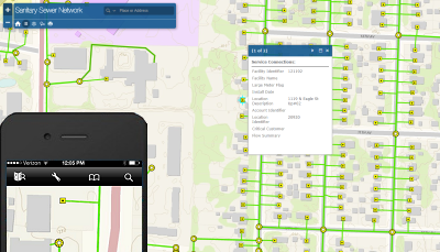
The map is designed to be used on a web browser, smartphone or tablet for staff to view an interactive sanitary sewer network map. The Sanitary Sewer Network map serves as a foundation for other solutions provided by ArcGIS for Water Utilities.
Requirements
Sanitary Sewer Network requires specific technical experience and software.
| Requirement | Description |
| Software |
Map authoring
Map service hosting
|
| Applications |
|
What you get
When you download the Sanitary Sewer Network map, you'll find the following in the zip file:
| Directory | Item | Description |
| Maps and GDBs | SanitarySewerNetwork.mxd | A map document used to publish the Sanitary Sewer Network service. |
| SanitarySewerNetwork.gdb | A sample geodatabase with sewer network data from the City of Naperville, Illinois. | |
| Icons | A folder containing icons for the services, maps, and apps. | |
What's new
Below are the release dates and notes for Sanitary Sewer Network.
| Date | Description |
| June 2020 |
|
| July 2015 |
|
| August 2014 |
|
| January 2014 |
|
| September 2013 |
|
You may be interested in