Overview

Beach Landing can be used to plan and execute amphibious operations.
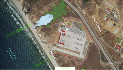
An amphibious operation is a military operation launched from the sea by an amphibious force to conduct landing force operations within the littorals. The littorals include those land areas (and their adjacent sea and associated air space) that are predominantly susceptible to engagement and influence from the sea. Amphibious operations require the unique ability to operate across air, land, and sea.
Personnel need to understand these environments and any physical hazards that could affect the operation. Features such as reefs, rocks, and dense vegetation could hamper the mission's effectiveness, cause damage or harm to equipment and personnel, and waste precious time. Knowing the location of these features allows planners and operators to increase awareness of possible hazards and aid in effective amphibious operation planning.
This solution illustrates how you can:
- Utilize the editing tools and layers to sketch the plan and identify hazard features.
- Manage marginal information in a layout.
Requirements
Beach Landing requires specific technical experience and software. Minimum system requirements for the ArcGIS Platform can be found on the Support website.
| Requirement | Description |
| Software |
Map Authoring
|
What you get
When you download Beach Landing, you will find the following:
| File | Folder | Description |
| BeachLanding.zip | ArcGIS Pro | Folder containing an ArcGIS Pro project template to get you started with beach landing workflows. |
| ArcMap | Folder containing sample data, toolboxes, and map document to get you started with beach landing workflows. | |
| Resources | Supporting files for Beach Landing. |
What's new
Below are the releases and notes for Beach Landing. If you need support, please contact Esri Support Services. If you'd like to get help from other defense community members, post your question on GeoNet.
| Date | Description |
| April 2018 |
|
| September 2017 |
|