This item has been moved to mature support. Capabilities are included in ArcGIS Pro 2.6 and later. Capabilities for ArcGIS Pro 2.2-2.5 and ArcMap 10.4.1-10.8.1 are available with Military Tools for ArcGIS.

Overview

Gridded Reference Graphic

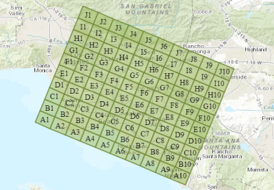
The Gridded Reference Graphic (GRG) solution allows you to create rectangular grids for use in partitioning geographic areas of interest. Gridded reference graphics can be used in a variety of operations, including search and rescue, cordon and search, and clearance operations.

This solution illustrates how you can:

  • Create rectangular grids for use in partitioning geographic areas of interest.
  • Create grids with either a starting point or area, based on either dimension or a reference system (MGRS and USNG).
  • Number point features.
  • Publish the Gridded Reference Graphic to ArcGIS Enterprise/Portal for ArcGIS for dissemination.

Requirements

The specific software and system requirements for the Gridded Reference Graphic solution are listed below.

Requirement Description
Software

What you get

When you download the Gridded Reference Graphic solution, you will find the following:

Component Folder Description
Geoprocessing Contains the Gridded Reference Graphic Python toolbox and supporting files.
Gridded Reference Graphic.pdf Help documentation for the Gridded Reference Graphic solution.

What's new

Below are the release notes for the Gridded Reference Graphic solution. If you need support, please contact Esri Support Services. If you'd like to get help from defense community members, post your questions on GeoNet.

Version Description
August 2018
April 2018
  • The Gridded Reference Graphic widget is now included with Web AppBuilder for ArcGIS
  • Issues addressed:
    • #585 Point Target GRG/Create GRG from Point output has undefined coordinate system
    • #625 Create Reference System GRG from Area gp tool does not check if input area falls into polar region
    • #646 Create GRG from Point tool should catch and handle case where no point dropped
January 2018
  • Added functionality for Create GRG from Area tool
    • Added kilometers, miles, nautical miles, and yards for cell units
    • Added label properties section
  • Added functionality for Create GRG from Point tool
    • Added kilometers, miles, nautical miles, and yards for cell units
    • Added label properties section
    • Added grid rotation capability
  • Added functionality for GRG widget
    • Added time and speed option when defining a grid by point
    • Added Alpha-Alpha, Alpha-Numeric, and Numeric options to label settings when creating a grid by reference system
  • Issues addressed:
    • #117 Define by Reference System by either area or point does not check if the input area is located in the MGRS polar regions (that is, north of 84º N or south of 80º S). When the user clicks Create GRG, no error message is displayed to inform the user why the output GRG was not created.
September 2017
  • Gridded Reference Graphic Widget:
    • Added capability to create a Gridded Reference Graphic (GRG) based on:
      • The Military Grid Reference System (MGRS) reference system
      • The United States National Grid (USNG) reference system
      • A drawn polygon
  • First release of Gridded Reference Graphic solution for ArcGIS Desktop. The solution contains geoprocessing tools that run in ArcGIS Pro and ArcMap, which allow you to:
    • Create grids with a starting point, based on either dimension or a reference system (MGRS and USNG)
    • Create grids with an area, based on either dimension or a reference system (MGRS and USNG)
  • Added offline documentation
December 2016
  • First release of Gridded Reference Graphic Widget

Get started with Gridded Reference Graphic

Top