Overview

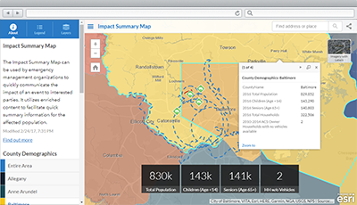
Impact Summary Map is a configuration of an Impact Summary application that can be used by the general public to understand the impact of an incident or event on at-risk populations.
The Impact Summary Map can be used by emergency management organizations to quickly communicate the impact of an event to interested parties. It utilizes enriched content to facilitate quick summary information for the affected population.
Requirements
To deploy Impact Summary Map with the ArcGIS Solutions Deployment Tool requires specific software.
| Requirement | Description |
| Software |
Solution deployment
Solution hosting
|
| Applications |
|
To manually deploy Impact Summary Map in your organization requires specific software.
| Requirement | Description |
| Software | Map authoring
GIS service hosting
|
| Application |
|
What you get
Impact Summary Map can be deployed in your ArcGIS organization without downloading the solution. When you deploy Impact Summary Map in your organization, you'll find the following:
| Item | Name | Description |
| Application | Impact Summary Map | An application used by the general public to understand the impact of an incident or event on at-risk populations. |
| Map | Impact Summary Map | A map used to display information about the current event and impacts to the community. |
| Feature layers | IncidentLocations | A feature layer used to store incident locations and information. |
| Demographics | A feature layer used to store demographic information. |
What's new
Below are the release dates and notes for Impact Summary Map.
| Date | Description |
| June 2019 |
|
| March 2019 |
|
There is a newer version...
Impact Summary Map (solution template) has been moved to mature support. Use the Impact Summary configurable app for future configurations in ArcGIS Online and ArcGIS Enterprise.