The ArcGIS Solutions website will no longer be available after September 1, 2025. See the latest documentation.
This item has been moved to mature support. Please see What's new for more information.
Overview
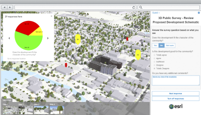
3D Public Survey is a configuration of ArcGIS and a JavaScript application that can be used by local governments to share 3D maps (scenes) online and engage with the community to solicit structured feedback on for example proposed property developments.
3D Public survey allows you to get quantifiable answers to specific questions you may want to ask your audience as well as gather feedback in the form of open comments.
Requirements
3D Public Survey require specific software.
| Requirement | Description |
| Software |
Scene authoring
GIS service hosting
Application hosting
|
| Browser compatibility |
The application is optimized for display on desktop computers using the following browsers:
|
What you get
When you download 3D Public Survey, you'll find the following files:
| Directory | Item | Description |
| Application | 3DPublicSurvey | A folder containing the 3D Public Survey application files. |
| MapsandGeodatabase | 3DPublicSurvey.aprx | An ArcGIS Pro project used to create and publish the 3D Public Survey responses layer. |
| 3DPublicSurvey.gdb | A geodatabase used to store your survey responses. | |
| SurveyConfigurations | A folder containing sample survey questions. | |
| 3DPublicSurvey.tbx | A toolbox with a tool used to import publish survey questions. |
What's new
Below are the release dates and notes for 3D Public Survey.
| Date | Description |
| October 2019 |
|
| January 2017 |
|
There is a newer version...
3D Public Survey has been moved to mature support and replaced with ArcGIS Urban.