Overview
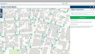
Adopta is a configuration of ArcGIS Web AppBuilder that can be used by government agencies and other organizations to engage the public in the operations and maintenance of natural and man-made assets. Adopta makes it easy for the public to volunteer for maintenance programs and have an ongoing dialog with an organization. Participation in maintenance programs allows the public to monitor, report, and care for assets throughout their community.
Adopta can be configured for many asset types (for example, catch basins, hydrants, parks, streams, trails, roads, vacant lots) and leverages email to simplify correspondence with the public. Feedback garnered from Adopta can be used to improve daily operations; and preparedness or response activities during an incident.
Requirements
Adopta requires specific software.
| Requirement | Description |
| Software |
Map authoring
GIS service hosting
|
| Application |
|
| Browser compatibility | The application is optimized for display on desktop computer, tablet, and smartphone devices using the following browsers:
|
What you get
When you download Adopta, you'll find the following files:
| Directory | Item | Description |
| Application | Adopta | A folder containing the Adopta widget files. |
| ArcREST | A folder containing the ArcREST files. | |
| EmailTemplates | A folder containing HTML templates. | |
| ToolBox | A folder containing tools for publishing an authenticated service used by the Adopta application. | |
| MapsandGeodatabase | CatchBasins.mxd | A map document used to publish the CatchBasin service. |
| Adopta.gdb | A sample geodatabase that includes the standard schema needed to publish the Asset service and user table used by the application. |
What's new
Below are the release dates and notes for Adopta.
| Date | Description |
| January 2020 |
|
| March 2017 |
|
| September 2016 |
|
You may be interested in
ArcGIS Solutions for Local Government includes several related maps and apps that also can be configured in your organization: