Overview
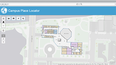
Campus Place Locator is a configuration of ArcGIS and a JavaScript application that offers a map-based view of interior and exterior assets on a university or business campus.
Campus Place Locator can be used by employees, students, and visitors to search for a building space or employee by name or to use the map and floor navigator to find an area of interest. When the search function is used, the application presents a list of spaces or employees with similar names, allowing the application user to select the appropriate space or employee. The application will then show the location of the employee or space on the campus map.
Requirements
Campus Place Locator requires specific software.
| Requirement | Description |
| Software |
Map authoring
GIS service hosting
Application hosting
|
| Browser compatibility |
The application is optimized for display on desktop computer, tablet, and smartphone devices using the following browsers:
|
What you get
When you download the Campus Place Locator, you'll find the following files:
| Directory | Item | Description |
| Application | CampusPlaceLocator | A folder containing the Campus Place Locator application files. |
| CampusCacheSettings.xml | A tiling scheme suitable for the Campus and other basemaps. | |
| MapsandGeodatabase | BuildingInterior.mxd | A map document used to publish the BuildingInterior service. |
| Campus.mxd | A map document used to publish the Campus Basemap tiled or cached service. | |
| CampusGreyScale.mxd | A map document used to publish the Campus Grey Scale Basemap tiled or cached service. | |
| LocalGovernment.gdb | ArcGIS for Local Government geodatabase with content from the City of Naperville, Illinois. |
What's new
Below are the release dates and notes for Campus Place Locator.
| Date | Description |
| December 2018 |
|
| March 2017 |
|
| June 2016 |
|
| August 2015 |
|