Overview
Crash Risks Briefing can be used to communicate the level of crash risk across the road network to key stakeholders within the organization.
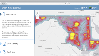
Agencies can use Crash Analysis to analyze crash data along roadways utilizing a risk-mapping protocol to create maps that show variations in the level of crash risk across a road network. These risk maps can then be shared in the Crash Risks Briefing application to help inform decisions on transportation infrastructure improvements and targeted enforcement strategies.
Requirements
To deploy Crash Risk Briefing with the ArcGIS Solutions Deployment Tool requires specific software.
| Requirement | Description |
| Software |
Solution deployment
Solution hosting
|
| Application |
|
What you get
Crash Risks Briefing can be deployed in your ArcGIS organization without downloading the solution. When you deploy Crash Risks Briefing in your organization, you'll find the following:
| Item | Name | Description |
| Application | Crash Risks Briefing | An application that can be used by transportation agencies to communicate the level of crash risk across the road network to key stakeholders. |
What's new
Below are the release dates and notes for Crash Risks Briefing.
| Date | Description |
| February 2021 |
|
| September 2018 |
|