This solution is now in mature support, but these scripts will continue to be maintained in GitHub. For more information please visit the Esri Product Life Cycle page.

Overview
Solutions Geoprocessing Toolbox

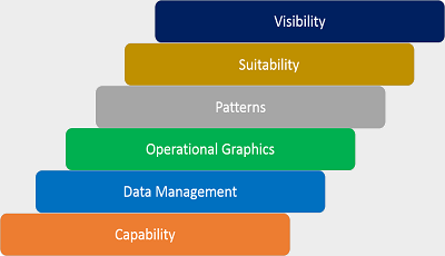
The Solutions Geoprocessing Toolbox contains specialized geoprocessing models and scripts to support defense and intelligence workflows including:

  • Tools for visibility and range analysis
  • Tools for analyzing the operational environment
  • Tools for data management and coordinate conversion
  • Tools for analyzing incidents to find patterns and trends
  • Tools for creating operational graphics

Developers interested in contributing can use the solution-geoprocessing-toolbox repository in GitHub. The repository contains the most up-to-date tools built on the most recent version of the ArcGIS Platform. See the README.md for more details.

Requirements

Geoprocessing tool requirements can vary by toolbox. Minimum system requirements for the ArcGIS Platform can be found on the Support website.

Requirement Description
Experience
  • Using geoprocessing tools in ArcGIS for Desktop (ArcMap or ArcGIS Pro)
  • Optional: Accessing the tools and scripts from GitHub requires experience with GitHub and Python
Software
  • The current version works with ArcGIS for Desktop 10.4 (Standard or Advanced), which includes ArcMap and ArcGIS Pro 1.1.
  • A ZIP archive utility to extract (unzip) the archive files
  • Some toolboxes may require:
    • Spatial Analyst Extension
    • 3D Analyst Extension
    • Network Analyst Extension
  • A Markdown editor/reader is helpful, but not required to read the .MD files.

What you get

Item Description
README.md Documentation for using the repository and also for each tool category
solutions-geoprocessing-toolbox-X.X.X-release-notes.md Release notes for version X.X.X
.tbx Toolboxes for ArcGIS for Desktop (including ArcMap and ArcGIS Pro)
.pyt Python toolboxes for ArcGIS for Desktop (including ArcMap and ArcGIS Pro)
.py Supporting Python script files
.lyr/.lyrx Supporting layer files

What's new

Version Notes
December 2016
  • This solution is in mature support.
2.2.0
  • Built for ArcGIS for Desktop 10.4 and ArcGIS Pro 1.1
  • This version includes:
    • Updated Military Aspects of Weather_10.4.tbx tools
    • Bug fixes and improvements, see solutions-geoprocessing-toolbox-2.2.0-release-notes.md for a list of fixes.
2.1.0
  • Built for ArcGIS for Desktop 10.3.1 and ArcGIS Pro 1.1
  • This version includes:
    • Military Aspects of Weather_10.3.tbx added for weather analysis.
    • Many bug fixes and tool improvements, see solutions-geoprocessing-toolbox-2.1.0-release-notes.md for list of fixes.
2.0.0
  • Built for ArcGIS for Desktop 10.3 and ArcGIS Pro 1.0
  • This version includes:
    • Many new toolboxes and tools added, including:
      • Movement Analysis Tools
      • LiDAR Elevation Tools_10.3.tbx
      • CADRG ECRG Tools.pyt
      • CIB Tool.pyt
      • Elevation Tools.pyt
      • Change Detection.tbx
      • Landsat Pre-Processing.tbx
    • Support for both ArcMap and ArcGIS Pro
    • See solutions-geoprocessing-toolbox-2.0.0-release-notes.md for list of fixes.
1.0.2
  • Built for ArcGIS for Desktop 10.2.2
  • This version includes:
    • Updates to environment\toolboxes\Build Elevation Mosaic Tools.tbx
    • Updates to tool validation in common\toolboxes\Visibility and Range Tools.tbx

Get started with Solutions Geoprocessing Toolbox

You may be interested in

Here is a list of helpful links to understand geoprocessing and coding with Python:

ArcGIS for Defense includes several maps and apps that can also be configured in your organization:

Top