Overview
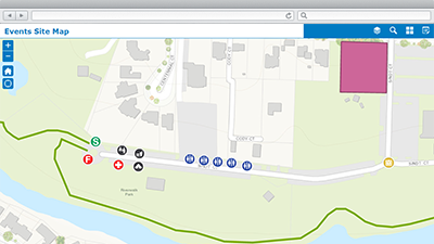
Events Site Map is a configuration of ArcGIS Web AppBuilder that can be used by event organizers or event coordinators to create site maps that accompany community, or special, events permit applications. Site maps typically include the event location, assets (for example, first aid stations, food tents, rest rooms), designated areas, and any routes required to conduct the event.
Event site maps and the accompanying permit applications are submitted to coordinators and reviewed by several government agencies during the permit review process. In addition, they become the foundation for operational and security plans developed to ensure the health and safety of event attendees.
Requirements
To deploy Events Site Map with the ArcGIS Solutions Deployment Tool requires specific software.
| Requirement | Description |
| Software |
Solution deployment
Solution hosting
|
| Application |
|
To manually deploy Events Site Map in your organization requires specific software.
| Requirement | Description |
| Software |
Map authoring
GIS service hosting
|
| Application |
|
What you get
Events Site Map can be deployed in your ArcGIS organization without downloading the solution. When you deploy Events Site Map in your organization, you'll find the following:
| Item | Name | Description |
| Application | Events Site Map | An application used by organizers and coordinators to create site maps that accompany event permit applications. |
| Map | Events Site Map | A map used in the Events Site Map application to create site maps that accompany event permit applications. |
| Feature layers | CommunityEventAssets | A feature layer used to store event routes, areas, and facilities that help event organizers and planners conduct community events. |
| CommunityEvents | A feature layer used to store events or festivals held once, or on a regular basis, which enhance the vitality, quality of life, and economic prosperity of a community. |
What's New
Below are the release dates and notes for Events Site Map application.
| Date | Description |
| August 2020 |
|
| January 2017 |
|
| June 2016 |
|
There is a newer version...
Events Site Map has been moved to mature support and can be replaced with Special Events Permitting and Operations.