Overview
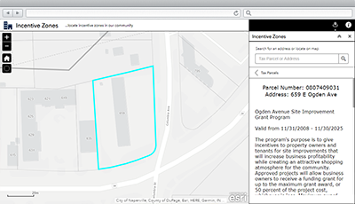
Incentive Zones is a configuration of ArcGIS Web AppBuilder that can be used by business owners and corporations to discover incentives that encourage new business, or the expansion of existing businesses, in a community. Economic development incentives are cash, or near-cash, assistance provided on a discretionary basis to induce growth in targeted areas, thus providing new jobs and long term positive tax revenue for State Governments.
This application can accessed from a smartphone, tablet, and desktop computer. Organizations can deploy a single application that includes local and state incentives; or deploy multiple applications (for example, local business incentives, state business incentives) that only include incentives from one or more levels of government.
Requirements
To deploy Incentive Zones with the ArcGIS Solutions Deployment Tool requires specific software.
| Requirement | Description |
| Software |
Solution deployment
Solution hosting
|
| Application |
|
What you get
Incentive Zones can be deployed in your ArcGIS organization without downloading the solution. When you deploy Incentive Zones in your organization, you'll find the following:
| Item | Name | Description |
| Application | Incentive Zones | An application used by businesses and corporations to discover incentives that encourage new business, or expansion of existing businesses, in a community. |
| Map | Incentive Zones | A map used in the Incentive Zones application to discover incentives that encourage new businesses, or the expansion of existing businesses, in a community. |
| Feature layers | IncentiveZones | A feature layer used to store areas where cash or near-cash incentives are provided to attract or retain businesses; or to increase property value in the area. |
| IncentiveZones_public | A public feature layer view of areas where cash or near-cash incentives are provided to attract or retain businesses; or to increase property value in the area. | |
| SiteAddresses | A feature layer used to store site or service delivery addresses. | |
| SiteAddresses_public | A public feature layer view of site or service delivery addresses. | |
| TaxParcels | A feature layer used to store divisions of land for the sole purpose of equitable taxation, combined with assessing and tax information from CAMA and Tax systems. | |
| TaxParcels_public | A public feature layer view of divisions of land for the sole purpose of equitable taxation, combined with assessing and tax information from CAMA and Tax systems. |
What's New
Below are the release dates and notes for Incentive Zones.
| Date | Description |
| June 2023 |
|
| March 2019 |
|
| January 2017 |
|
| June 2014 |
|