Overview
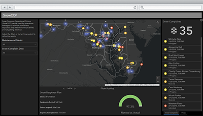
SnowCOP can be used to monitor snow event responses and determine which streets are not getting attention.
The dashboard leverages visualizes real-time locations of vehicles and assets. The feeds can be used to visualize the location of vehicles and other assets used in your snow response plan. If you use a different automated vehicle location (AVL) application for your vehicles or assets, you can configure the SnowCOP map to leverage feeds from your AVL vendor.
Finally, SnowCOP provides public works or transportation directors a jurisdiction-wide view of snow response activities to ensure performance standards are met; and district managers a focused view of their maintenance district so they can effectively assign resources during a response.
Requirements
To deploy SnowCOP with the ArcGIS Solutions Deployment Tool requires specific software.
| Requirement | Description |
| Software |
Solution deployment
Solution hosting
|
| Application |
|
What you get
SnowCOP can be deployed in your ArcGIS organization without downloading the solution. When you deploy SnowCOP in your organization, you'll find the following:
| Item | Name | Description |
| Application | SnowCOP | An application used by public works operations managers to monitor snow event response activities. |
| Map | SnowCOP | A map used in the SnowCOP application to monitor snow event response activities. |
| Feature layers | CitizenProblems | A feature layer used to store non-emergency problems reported by general public. |
| SnowResponsePlans | A feature layer used to plan and track resource assignments and plow activity during snow storm responses. | |
| SnowIceProblems_dashboard | A feature layer view used to monitor reports of snow or ice problems reported by general public. |
What's New
Below are the release dates and notes for SnowCOP.
| Date | Description |
| November 2021 |
|
| January 2019 |
|
| June 2018 |
|
| September 2016 |
|
| August 2015 |
|