Overview
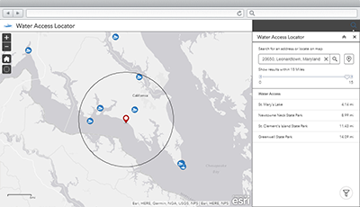
Water Access Locator is a configuration of ArcGIS Web AppBuilder that can be used by anglers and boaters to locate public access ramps and obtain information about amenities at the access site.
Water Access Locator is typically used by fish and wildlife departments, natural resource departments, or other state government agencies responsible for promoting water access sites. It provides access to the organization 24 hours a day, seven days a week, and typically supplements static websites or customer service phone numbers staffed by government organizations.
Requirements
To deploy Water Access Locator with the ArcGIS Solutions Deployment Tool requires specific software.
| Requirement | Description |
| Software |
Solution deployment
Solution hosting
|
| Application |
|
To manually deploy Water Access Locator in your organization requires specific software.
| Requirement | Description |
| Software | Map authoring
GIS service hosting
|
| Application |
|
What you get
Water Access Locator can be deployed in your ArcGIS organization without downloading the solution. When you deploy Water Access Locator in your organization, you'll find the following:
| Item | Name | Description |
| Application | Water Access Locator | An application used by anglers and boaters to locate public access ramps and obtain information about amenities at the access site. |
| Map | Water Access Locator | A map used in the Water Access Locator application to locate public access ramps and obtain information about amenities at the access site. |
| Feature layer | Water Access | A feature layer used to store public access ramps and obtain information about amenities at the access site. |
What's new
Below are the release dates and notes for Water Access Locator.
| Date | Description |
| January 2019 |
|
| December 2017 |
|