This item has been moved to mature support. Please see What's new for more information.

Overview

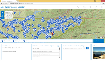
Water Access Locator is a configuration of ArcGIS and a JavaScript application that allows citizens to locate boat ramps, marinas, and fishing sites in the state from a smartphone, tablet, and desktop computer.

Water Access Locator is typically used by fish and wildlife and natural resources organizations, or other state government organizations responsible for recreational activities. This application provides access to the organization 24 hours a day, seven days a week.

Requirements

Water Access Locator requires specific software.

Requirement Description
Software
Map authoring
  • ArcMap 10.4 - 10.6
  • ArcGIS Online
GIS service hosting
  • ArcGIS Online, or
  • ArcGIS 10.4 for Server (Standard or Advanced), or
  • ArcGIS Enterprise 10.5 - 10.6 (Standard or Advanced)
Application hosting
  • Microsoft Internet Information Services (IIS) 7.0 or higher
  • Microsoft ASP.NET Framework 4.0 or 4.5
Browser compatibility

The application is optimized for display on desktop computer, tablet, and smartphone devices using the following browsers:

  • Microsoft Internet Explorer 10, 11
  • Mozilla Firefox
  • Google Chrome
  • Apple Safari

What you get

When you download the Water Access Locator, you'll find the following files:

Directory Item Description
Application WaterAccessLocator A folder containing the Water Access Locator application files.
MapsandGeodatabase WaterAccess.mxd A map used to publish the WaterAccess service.
StateGovernment.gdb State Government geodatabase with sample data.

What's new

Below are the release dates and notes for Water Access Locator.

Date Description
December 2017
  • This application has been moved to mature support and replaced by the Water Access Locator.
September 2017
  • Sample data updated.
January 2017
  • A collection of fixes to the application's popup behavior.
  • An update to the application's configuration file to improve search results coming from the updated geocoding service.
September 2016
  • Sample data updated
February 2016
  • Added the ability to clear the current search results using the "X" button on the search panel
  • Added a buffer slider that can be used to interactively define the buffer distance when searching
  • Added an enhancement that provides the ability to set the search location by clicking on the map
  • Added the "Yes"/"No" values for activity searching as configurable items in the config.js file
August 2015
  • A series of enhancements that improve support for custom popups and numeric 1000 separators in pop-ups
  • An enhancement that improves map navigation and zoom behavior when a search is executed
  • A resolution to a bug that caused layers to be queried unnecessarily
  • A resolution to a bug that prevented the legend from displaying correctly when symbols were updated in the map
  • A resolution to a bug that caused the pop-up header to display incorrectly on smartphone devices
  • A series of enhancements that improve search behavior on smartphone devices
July 2015
  • First release of Water Access Locator

Get started with Water Access

Top