Overview
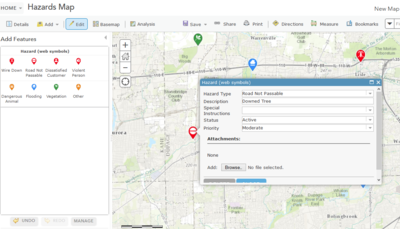
The Hazard Reporting Collector solution allows field personnel to record the location of hazards with their smartphone or tablet in the field. This solution also allows the user to attach a photo with additional details about the hazard. By creating a map of hazards from the field, managers and dispatch can see potential hazards that can impact field crews and work locations.
The Hazard Reporting Collector is a configuration of ArcGIS. Once configured, the Hazard Reporting Collector can be access by field crews using the ArcGIS Collector app. This allows personnel to collect hazard information regardless of connectivity to the office network, assuming cellular coverage is available.
Requirements
Hazard Reporting Collector requires specific technical experience and software.
| Requirement | Description |
| Software |
Solution deployment
Solution hosting
|
| Applications |
|
What you get
When you deploy Hazard Reporting Collector, you'll find the following:
| Item | Name | Description |
| Map | Hazard Collection | A map by field technicians to add hazards in the field. |
| Feature layer | Hazards | A feature layer used to store hazards collected in the field. |
What's new
Below are the release dates and notes for Hazard Reporting Collector.
| Date | Description |
| November 2020 |
|
| June 2017 |
|
| January 2017 |
|
| August 2015 |
|